

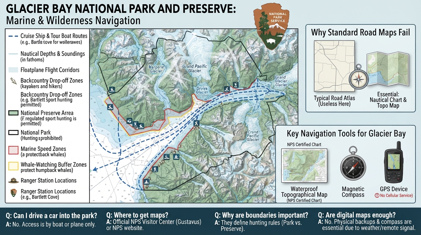
A Glacier Bay National Park and Preserve map looks completely different from any traditional highway map or city street guide you might use on a typical vacation. Glacier Bay National Park and Preserve is made up of massive tidewater glaciers, deep ocean fjords, jagged mountain peaks, and dense wilderness with almost zero asphalt roads on land. Visitors cannot simply rent a car and drive through the protected area, meaning a standard road atlas becomes entirely useless for your journey. Instead, any accurate Glacier Bay National Park and Preserve map must focus heavily on marine channels for cruise ships and tour boats, narrow airplane flight paths, backcountry drop-off zones for brave hikers and kayakers, and distinct federal ranger boundaries. Furthermore, the massive property is split into a heavily visited National Park and a surrounding National Preserve where different rules apply for activities like regulated sport hunting, which makes understanding the specific boundaries on your map essential for staying compliant with federal guidelines.
Why Traditional Highway Maps Fail in This Region
Standard driving maps fail in this unique region because the landscape of Glacier Bay National Park and Preserve consists almost entirely of icy ocean waters, steep mountain walls, and remote shores without any connecting highway network. Traditional car travel is physically impossible across the vast majority of the protected area, meaning your navigation tools must rely on maritime channels, nautical depths, and floatplane flight corridors instead of exit numbers and rest stops. Visitors must quickly adjust their travel expectations when reviewing cartography for southeast Alaska, where large vessels, small tour boats, and bush planes serve as the only true vehicles for exploration. Without a clear understanding of this maritime layout, travelers often feel disoriented upon realizing that standard overland shortcuts simply do not exist here.
Sourcing Certified Cartography from Federal Authorities
Reliable cartography for Glacier Bay National Park and Preserve is available directly through official federal channels, primarily via the National Park Service website and the physical visitor center situated in Gustavus, Alaska. The National Park Service provides waterproof topographical printouts for backcountry hikers alongside digital PDF charts that clearly highlight park boundaries, marine speed zones, and ranger stations. Relying on these official publications ensures you receive up-to-date details on seasonal wildlife closures, vessel quotas, and emergency radio frequencies before you step foot into the remote Alaskan environment. Downloading unofficial third-party maps from random internet blogs often leaves visitors without critical safety updates or accurate nautical markers, which can create serious hazards on the water.
Decoding Marine Channels and Protected Waters
Marine zones dictate almost every movement within the icy coastal waters of Glacier Bay National Park and Preserve. The official chart marks strict speed limits, whale-watching buffer zones, and designated vessel routes designed specifically to protect humpback whales, harbor seals, sea otters, and nesting seabirds. Cruise ships, tour vessels, and private kayakers must share these complex waterways while adhering strictly to boundaries enforced by park rangers and the National Park Service. Understanding these marine restrictions prevents accidental incursions into sensitive wildlife habitats and keeps recreational boaters safe from hidden underwater hazards like submerged glacial ice chunks.
Navigating Land Boundaries Between Park and Preserve
Understanding the exact line separating the strict national park from the surrounding national preserve is vital for anyone stepping off a boat onto dry land. According to the National Park Service, recreational sport hunting is permitted within the national preserve boundaries under specific state and federal guidelines, whereas all hunting and firearms are strictly prohibited within the national park district itself. Backcountry camping permits are also required for overnight stays in designated zones, and hikers must carry bear-resistant food containers as mandated by park management rules to protect local wildlife populations. For travelers interested in wider regional wilderness planning, studying how other rugged parks handle remote trail logistics offers helpful context, much like reviewing a glacier national park backcountry map when preparing for deep alpine trips.
Coping With Digital Blind Spots and Weather Hazards
Relying solely on digital smartphone maps can be dangerous in a remote wilderness featuring zero cellular reception and rapidly shifting coastal weather patterns. Sudden heavy storms, dense fog, and strong tidal currents can alter travel plans within minutes, making a physical backup map and a reliable magnetic compass vital gear items for every traveler. Visitors should always check current weather advisories and marine forecasts directly through the National Park Service before embarking on any backcountry trek or independent boating excursion to avoid unexpected hypothermia or navigation errors.
Common Questions About Glacier Bay National Park and Preserve Maps
Can I drive my personal car into Glacier Bay National Park and Preserve?
No, there are no roads leading into the main park wilderness, so visitors arrive by boat or airplane instead of traditional automobiles.
Where can I get a waterproof trail map for Glacier Bay?
Waterproof topographical maps are available at the park visitor center in Gustavus and online via official National Park Service publications.
Do I need a permit to explore the backcountry shown on the map?
Yes, overnight backcountry camping requires a free permit from the National Park Service during the core summer visitor season.
What is the difference between the park and the preserve sections?
The national park prohibits hunting, while the surrounding national preserve allows regulated sport hunting under state and federal guidelines according to the National Park Service.
Are digital phone maps reliable for navigation here?
Cellular service does not exist across most of the park, making offline digital maps and physical paper backups necessary for safety.
Who manages the rules and regulations marked on the map?
The National Park Service oversees all visitor guidelines, wildlife protection zones, and backcountry permits within the region.

I’m Muhammad Ubaid, founder of YBR Magazine. I research and write detailed guides on America’s National Parks — covering entry fees, permits, best times to visit, and planning tips — using official NPS sources and up-to-date information.

