

Volcanic Caldera Geography and High Elevation Challenges
Planning a trek through Crater Lake National Park means preparing for a high-altitude mountain environment where the dramatic volcanic landscape dictates every step of the journey.
Crater Lake National Park sits high in the Cascade Mountains of Oregon, with the volcanic rim resting between seven thousand and eight thousand feet above sea level. This high altitude means that heavy snow lingers on many trails well into July or even August during heavy snow years. Visitors should always check current trail conditions with the National Park Service before arriving, as weather can change fast even in the middle of summer. Afternoon thunderstorms bring sudden lightning risks to exposed rim trails, and high-altitude sun exposure is intense. Furthermore, natural water sources are extremely scarce along the rim, meaning hikers must pack all the drinking water they will need for their journey.
Panoramic Rim Overlooks and High-Altitude Vista Routes
Finding the best hikes in Crater Lake National Park for caldera views means looking for trails that climb above the rim for sweeping, wide-angle vistas of the deep blue water and Wizard Island.
Watchman Peak Trail is a top choice for panoramic views, offering a moderate climb that leads to a historic fire lookout station perched high above the western rim. The trail is roughly one mile each way, making it manageable for most visitors who are acclimated to the altitude, though the final push involves steady switchbacks. Another fantastic option is Mount Scott Trail, which leads to the highest point in Crater Lake National Park at nearly nine thousand feet. Climbing Mount Scott rewards hikers with a 360-degree view that stretches far beyond the caldera into the surrounding Cascade Range. Both of these rim trails lack shade, so starting early in the morning helps avoid both midday heat and afternoon storm clouds.
Navigating Cleetwood Cove Trail Down to the Shoreline
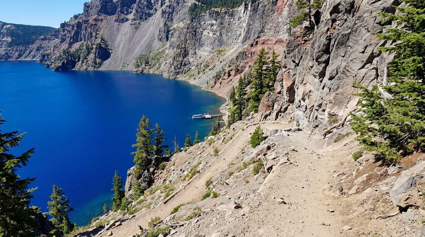
Cleetwood Cove Trail is the sole legal and official route that allows visitors to hike all the way down to the shoreline of Crater Lake.
Cleetwood Cove Trail drops about seven hundred feet in just over a mile, descending steeply down the inner wall of the volcanic caldera. While walking down to the water feels relatively easy, hikers must remember that the return trip is a grueling uphill climb at high elevation. The trail surface consists of loose dirt and gravel, which can cause slipping if hikers do not wear sturdy footwear with good traction. Swimming in the lake is permitted only at the bottom of Cleetwood Cove, and boat tours also depart from this shoreline during the summer months when concession operations are active.
National Park Service Regulations, Entrance Fees, and Restrictions
Visitors must follow strict guidelines set by the National Park Service to protect the fragile volcanic landscape and ensure personal safety.
According to the National Park Service, a standard vehicle entrance fee is required to enter Crater Lake National Park, and passes can be purchased at the entrance gates or online in advance. Pets are heavily restricted on trails throughout Crater Lake National Park to protect local wildlife and keep domestic animals safe from steep drop-offs and predators. Pets are generally only allowed on paved roads, parking areas, and very specific paved paths like sections of the Godfrey Glen Trail. Hikers must also stay on marked trails at all times, as venturing onto the steep caldera walls causes severe erosion and carries a high risk of dangerous rockfall.
Frequently Asked Questions About Exploring Crater Lake Trails
Here are answers to some of the most frequent questions visitors ask before exploring the trails.
When is the best time of year to hike in Crater Lake National Park?
The main hiking season runs from July through September, when most snow has melted and park roads are fully open.
Do I need a permit for day hiking at Crater Lake?
Day hiking does not require a special permit, but standard park entrance fees apply to all arriving vehicles.
Are dogs allowed on Crater Lake hiking trails?
Pets are prohibited on nearly all dirt trails within Crater Lake National Park to protect wildlife and ensure safety along the steep rim edges.
How difficult is the hike down to the water?
Cleetwood Cove Trail is moderately steep on the way down, but the return climb up to the rim is very strenuous due to the elevation gain.
Is drinking water available along the trails?
Natural water sources are scarce or untreated, so hikers must bring all the drinking water they need for their trek.
Can I hike Crater Lake in the winter?
Winter hiking and snowshoeing are possible, but heavy snow closes most rim roads, limiting access primarily to cross-country routes.
For outdoor enthusiasts looking for more majestic mountain peaks after visiting the Pacific Northwest, you can read our guide on choosing the best hikes in Grand Teton National Park for additional high-altitude trail inspiration.
Disclaimer: Park rules, trail conditions, and seasonal opening dates can change due to weather and maintenance. Always verify current conditions and fee structures directly with the National Park Service before planning your trip.

I’m Muhammad Ubaid, founder of YBR Magazine. I research and write detailed guides on America’s National Parks — covering entry fees, permits, best times to visit, and planning tips — using official NPS sources and up-to-date information.

