

Navigating the Desert Landscapes of the Mighty Five
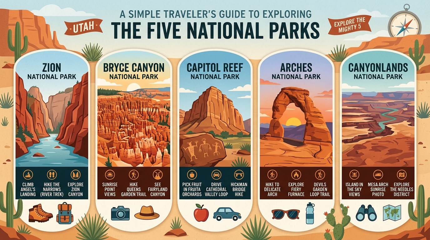
The group known as the Mighty Five includes five national parks Utah protects within its borders: Zion, Bryce Canyon, Capitol Reef, Arches, and Canyonlands.
These five national parks Utah locations sit across the southern and southeastern parts of the state. Each destination offers a completely different landscape, ranging from deep sandstone gorges to high-elevation amphitheaters filled with rock spires. Travelers planning a road trip through the region need to understand how these environments differ from one another before setting out on the road. Navigating this vast desert region involves managing varying elevations, rapidly shifting weather patterns, and differing crowd levels across each unique federal property.
Experiencing the Towering Red Sandstone of Zion
Zion National Park features towering red sandstone cliffs, deep canyon floors, and lush streamside vegetation.
Visitors to Zion National Park often spend their time walking along the Virgin River or gazing up at massive stone monoliths like the Great White Throne. During peak seasons, the main scenic canyon requires using a park shuttle system to manage vehicle congestion and protect local habitats. Walking trails range from easy paved riverside paths to strenuous climbs up narrow rock ridges like Angels Landing. Travelers should always check local weather updates before entering narrow canyons because sudden thunderstorms can create dangerous flash flood conditions with very little warning.
Wandering Among the Colorful Hoodoos of Bryce Canyon
Bryce Canyon National Park is famous for its massive natural amphitheaters packed with thousands of thin, colorful rock spires called hoodoos.
Situated at a much higher elevation than its neighbors, Bryce Canyon National Park experiences cooler temperatures and frequent winter snowfalls. Visitors can peer down into the main amphitheater from high viewpoints or hike down trails that wind directly among the towering stone pillars. Sunrise and sunset offer the most striking lighting for photography across the orange and pink rock formations. Because parts of the rim sit well over eight thousand feet above sea level, visitors sometimes experience mild altitude fatigue during strenuous hikes and need to drink plenty of water.
Discovering the Historic and Geological Folds of Capitol Reef
Capitol Reef National Park protects a long, wrinkle-like geological fold in the earth’s crust known as the Waterpocket Fold.
This quieter destination preserves a rich pioneer history alongside its colorful cliffs, domed rock formations, and deep canyons. Visitors to Capitol Reef National Park can explore historic orchards planted by early settlers, view ancient rock art left by indigenous peoples, and drive along unpaved dirt tracks that lead deep into the backcountry. The uncrowded atmosphere provides a peaceful break from the busier tourist hubs located elsewhere in the state. Local ranger programs and historic buildings offer deep educational value for families and history enthusiasts traveling through the region.
Exploring the Natural Stone Arches of Arches
Arches National Park contains over two thousand natural sandstone arches, ranging from tiny openings to massive spans.
The landscape of Arches National Park features balanced rocks, steep fins, and weathered stone arches carved by millions of years of erosion. Because visitor numbers are very high, management utilizes timed-entry reservation systems during busy months to control traffic flow and parking availability. Checking current entry rules well in advance is essential for anyone hoping to visit this iconic area. Popular walking paths lead visitors right up to famous formations like Delicate Arch, where afternoon heat requires careful preparation and early morning starts.
Taking in the Vast Rugged Canyons of Canyonlands
Canyonlands National Park preserves a vast, rugged wilderness of deep canyons carved by the Colorado River and its tributaries.
The park is divided into distinct districts, including Island in the Sky and The Needles, which are separated by deep river gorges and require hours of driving to visit between one another. Canyonlands National Park offers vast panoramic views from high canyon rims, making it a favorite spot for travelers seeking wide-open spaces and remote wilderness experiences. Because facilities are sparse in certain remote corners of the park, visitors must carry extra water, food, and emergency supplies before venturing down long unpaved roads.
Mapping Out Distances and Travel Logistics Between Destinations
Planning a trip across these destinations requires understanding that the five national parks Utah maintains are spread out across significant geographic distances.
Driving times between individual parks can range from one hour to several hours depending on the route chosen. Travelers should also consider how seasonal weather changes, from summer desert heat to winter snowstorms at higher elevations, might affect driving conditions. For a broader perspective on regional road trips, you can read our stunning desert highway route overview to help map out your driving schedule and accommodations.
Frequently Asked Questions
How long does it take to visit all five parks?
Most travelers spend between seven to ten days visiting all five parks to allow enough time for driving and exploring.
When is the best time of year to visit?
Spring and autumn offer the most comfortable daytime temperatures for outdoor walking and hiking.
Do I need reservations to enter every park?
Only certain parks, such as Arches, require timed-entry reservations during peak visitor seasons, so check official rules before you go.
Are pets allowed on the hiking trails?
Pets are heavily restricted on dirt trails in most of these parks to protect local wildlife and fragile desert soils.
Can I visit all five parks using a single park pass?
Yes, the America the Beautiful interagency annual pass covers admission to all five federal park locations.
How far apart are the parks from each other?
Driving distances vary, with some parks like Arches and Canyonlands sitting very close to Moab, while others require two or more hours of driving.
What should I pack for a desert road trip?
Pack plenty of drinking water, sturdy hiking footwear, sun protection layers, and offline maps since cellular service can be unreliable.
Disclaimer: Park rules, shuttle schedules, and reservation systems change frequently. Always verify current operating details through official park websites before planning your trip.

I’m Muhammad Ubaid, founder of YBR Magazine. I research and write detailed guides on America’s National Parks — covering entry fees, permits, best times to visit, and planning tips — using official NPS sources and up-to-date information.

