

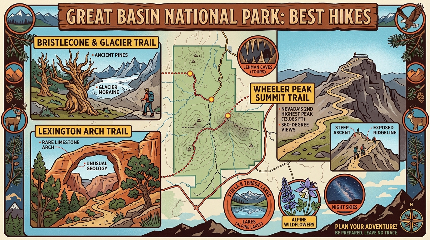
Planning a mountain adventure requires careful preparation, especially when you want to experience Great Basin National Park’s best hikes. Great Basin National Park sits in a very isolated region of eastern Nevada, far away from major highways and large cities. Because the park is so remote, visitors face unique physical challenges that do not exist in busier places like Zion National Park or Yosemite National Park. The park sits at a very high elevation, with many popular trailheads starting near 10,000 feet above sea level. This high starting point means altitude sickness is a real risk for hikers traveling directly from lower elevations. Furthermore, Great Basin National Park is famous for two very distinct natural wonders: ancient bristlecone pine trees that have lived for thousands of years, and the underground Lehman Caves. A smart hiking guide must address the physical reality of thin air, long driving distances between trailheads, and the seasonal weather limits that close high-country paths for much of the year.
Navigating High-Altitude Trailheads on Wheeler Peak
Before choosing a specific trail, visitors must understand the park’s high-altitude environment and seasonal weather limits.
Great Basin National Park is unique because you can drive up Wheeler Peak Scenic Drive to access high-elevation trailheads very quickly. However, this quick gain in elevation puts heavy stress on the human body. Hikers should drink plenty of water, pace themselves, and watch for headaches or dizziness, which are early signs of altitude sickness. Weather in the Snake Range changes very fast. A clear, sunny morning can turn into a powerful afternoon thunderstorm with lightning and hail, particularly during the summer monsoon season. High-country trails are often blocked by deep snow well into June, and winter weather can return as early as September. Checking in with park rangers at the visitor center before setting out helps ensure you know current trail conditions and weather forecasts.
Walking Among Ancient Bristlecone Pines
The Bristlecone Trail to the glacier site offers a fascinating walk past some of the oldest living trees on Earth and Nevada’s only active glacier.
This trail begins at the Wheeler Peak Campground parking area and climbs gently through a subalpine forest of spruce and fir trees. As you hike higher, the landscape opens up, revealing ancient bristlecone pines with twisted, weathered trunks shaped by centuries of harsh wind and freezing temperatures. Some of these remarkable trees have lived for over 4,000 years. Continuing past the bristlecone grove brings you to the foot of Wheeler Peak, where a small rock glacier sits tucked beneath a massive limestone cliff. According to the National Park Service, visitors should stay on established paths to protect these fragile alpine ecosystems and ancient trees from damage.
Tackling the Wheeler Peak Summit Climb
The Wheeler Peak Summit Trail provides the ultimate physical challenge and panoramic views for experienced hikers willing to tackle high-altitude terrain.
Reaching the summit of Wheeler Peak requires climbing to 13,063 feet above sea level, making it one of the highest points in Nevada. The trail is roughly 8.6 miles round-trip and gains over 2,900 feet of vertical elevation. Because the upper sections of the route travel above the tree line across exposed alpine tundra, hikers must start very early in the morning to avoid afternoon lightning storms. The thin air makes every step feel much harder than it would at sea level. The reward for your hard work is an incredible view stretching across vast desert valleys and neighboring mountain ranges. Downsides include heavy physical exhaustion, steep scree slopes that require careful footing, and biting wind at the summit.
Exploring the Alpine Lakes Loop Basin
The Alpine Lakes Loop offers a scenic and moderate way to experience high-mountain lakes and glacial basins without climbing to a massive mountain peak.
This loop trail connects Stella Lake and Teresa Lake, taking hikers through scenic evergreen forests and open meadows. The trail is much shorter and less demanding than the Wheeler Peak Summit Trail, making it a great option for families or visitors who are still adjusting to the altitude. Interpretive signs along the way share information about the local plants, animals, and glacial history of the park. Parking at the trailhead can fill up quickly during peak summer weekends, so arriving early in the morning is strongly advised. A practical downside is that mosquitoes can be quite bothersome near the water during mid-summer, so bringing insect repellent is a smart idea.
Descending Into the Subterranean Lehman Caves
Lehman Caves and the park’s surface walking paths provide wonderful underground and low-stress options for days when high-altitude hiking is too tiring.
Located near the main visitor center, Lehman Caves features stunning underground chambers filled with delicate stalactites, stalagmites, and rare helictites. According to the National Park Service, cave tours require advance reservations and tickets must be purchased ahead of time because group sizes are limited. Touching the cave formations is strictly prohibited because skin oils can permanently damage the living rock. For visitors looking for easy outdoor walks, the Mountain View Trail and other short paths near the visitor center offer gentle strolls with beautiful views of the valley floor without the heavy strain of high-elevation climbing.

Managing Remote Wilderness Logistics and Regulations
Following official National Park Service guidelines on safety gear, park rules, and weather tracking keeps visitors safe in this remote environment.
There is no entrance fee to enter Great Basin National Park, but guided tours of Lehman Caves do require a paid ticket. Cell phone service is extremely limited or entirely absent throughout most of the park, so you should download offline maps and trail guides before you arrive. Hikers must always carry extra layers of clothing, rain gear, plenty of water, and high-energy snacks because weather conditions shift rapidly in the mountains. For those looking to expand their mountain adventures in other scenic regions, our guide on Glacier National Park’s best hikes offers helpful comparisons for alpine trail planning. Always check current conditions with park rangers before heading out onto remote trails.
What is the best time of year to hike in Great Basin National Park?
The best time for high-elevation hiking is generally July through September when trails are mostly clear of snow.
Do I need a reservation to visit Great Basin National Park?
There is no entrance fee or reservation required to enter the park, but guided tours of Lehman Caves require advance tickets.
How high are the hiking trails in the park?
Most trailheads start near 10,000 feet, and summit routes can climb above 13,000 feet.
Is altitude sickness a real concern here?
Yes, because many trails begin near 10,000 feet, visitors coming from lower elevations often experience headaches, fatigue, or dizziness.
Are dogs allowed on hiking trails in Great Basin National Park?
Pets are restricted to paved areas, roads, and campgrounds to protect local wildlife and plant life, and are not allowed on dirt hiking trails.
Is there cell phone service inside the park?
Cell phone service is very limited or nonexistent across most of the park, so offline maps are essential.
Disclaimer: Park regulations, weather conditions, and tour schedules can change. Always verify current details directly with official sources like the National Park Service before planning your trip.

I’m Muhammad Ubaid, founder of YBR Magazine. I research and write detailed guides on America’s National Parks — covering entry fees, permits, best times to visit, and planning tips — using official NPS sources and up-to-date information.

