

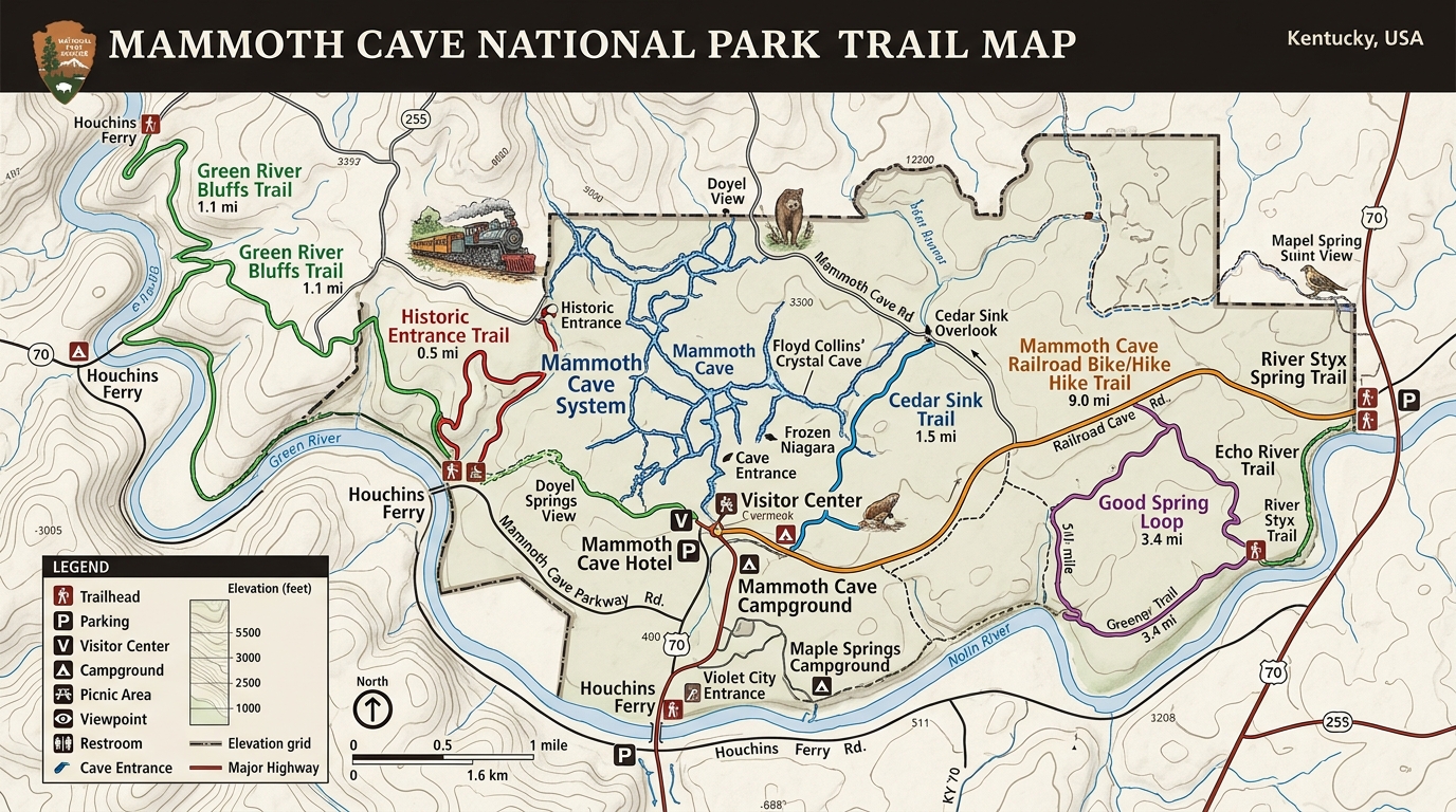
Mammoth Cave National Park protects the longest known cave system in the world, which draws millions of visitors underground every year. Yet that subterranean focus often overshadows the nearly 84 miles of forested surface paths winding across ridge tops and river valleys. Navigating these above-ground routes requires a specialized guide because a standard park layout must reconcile dense wilderness hills with complex subterranean features below. Using an official Mammoth Cave National Park trail map is the only dependable way to bridge that gap and explore the surface safely.
Connecting Surface Paths to Underground Features
A true Mammoth Cave National Park trail map does more than show forest dirt tracks; it reveals how surface topography relates directly to the limestone labyrinth beneath your feet.
When you stand on a wooded ridge looking at a standard topographical drawing, you might not realize that a massive underground cavern sits just a few hundred feet beneath your boots. The official cartography highlights unique geological formations like collapsed sinkholes, underground river resurgences, and historic stone saltpeter vats that sit right alongside surface hiking paths. Understanding these map symbols prevents you from wandering blindly past fascinating historical markers or losing track of your proximity to official cave tour portals. Without this spatial context, hikers often miss the intricate connection between the green rolling hills of Kentucky and the deep, dark world hidden underneath.
Mastering Backcountry Junctions and Remote Ridge Terrain
Reading a Mammoth Cave National Park trail map carefully is essential because remote backcountry trail junctions can easily confuse even experienced wilderness hikers.
The park’s surface trail network is split into frontcountry loops near the visitor center and rugged backcountry corridors stretching toward the Green River and the Collie Ridge areas. Many trail intersections in the outer zones feature wooden signposts that can weather away or become obscured by dense summer foliage. When you trace your intended route on the paper or digital map before leaving the trailhead, you create a mental checklist of upcoming junctions and stream crossings. This proactive navigation minimizes the risk of taking a wrong turn onto horse trails or park maintenance roads that can add miles of unplanned walking to your day.
Topographically Challenging Routes Worth Mapping Out
Exploring the best routes on a Mammoth Cave National Park trail map reveals a surprising variety of steep river bluffs and secluded sinkhole basins.
For a demanding workout that showcases river geology, the Green River Bluffs Trail climbs steadily away from the visitor hub and offers steep ascents over rocky terrain. If you prefer geological curiosities, mapping out a loop toward Cedar Sink brings you to a massive open-air sinkhole where an underground river briefly breaks into the daylight before vanishing back into limestone cracks. According to park rangers, these surface paths demand respect due to hidden tree roots, loose gravel on steep slopes, and summer humidity that drains your energy much faster than flat walking. Keeping your map open and tracking your mileage ensures you complete these loops before exhaustion sets in.

Environmental Hazards and Practical Downside Realities
Examining the practical limitations on a Mammoth Cave National Park trail map helps visitors prepare for backcountry hazards like seasonal mud, ticks, and absent cell signals.
Surface hiking at Mammoth Cave comes with genuine environmental challenges that catch unprepared visitors off guard during warm months. Cell phone towers fail frequently across deep river valleys and heavy forest cover, meaning digital mapping apps on your smartphone will often display a frustrating loading wheel instead of your current GPS location. Ticks, chiggers, and poison ivy thrive along grassy trail edges, requiring long pants, thick socks, and chemical repellents. Furthermore, natural water sources found along the surface trails are completely unsafe for drinking without rigorous purification treatment, so you must pack all your hydration needs from the start. For those collecting memories of multiple destinations, using a resource like a handy log for tracking US park adventures lets you document every successful hike while keeping your gear checklist organized.
Frequently Asked Questions About Mammoth Cave Trails
Where can I get a reliable trail map before starting my hike?
You can pick up a free physical map at the main Mammoth Cave National Park Visitor Center or download an official PDF copy directly from the National Park Service website.
Is cell phone service dependable on the surface trails?
Cellular coverage is notoriously patchy and completely absent in many remote valleys and wooded backcountry sectors of the park.
Are dogs permitted on the surface hiking trails?
According to the National Park Service, pets are allowed only on a very limited selection of paved paths near the visitor center and are banned from all backcountry dirt trails and underground cave tours.
Do I need to buy a ticket or permit to hike above ground?
According to the National Park Service, exploring the surface trail system is free of charge, whereas guided underground cave tours require advance reservations and paid tickets.
What should I do if a trail is flooded or blocked?
Turn back immediately if high water or downed trees block your path, and report the obstruction to staff members at the visitor center so they can update trail maintenance boards.
Are the surface trails maintained throughout the entire year?
Park crews maintain the trail corridors year-round, though winter storms and heavy spring rains can cause temporary muddy conditions or unexpected closures.
Disclaimer: Trail conditions, weather hazards, and park regulations change throughout the year. Always verify current status and safety guidelines with official sources before heading out.

I’m Muhammad Ubaid, founder of YBR Magazine. I research and write detailed guides on America’s National Parks — covering entry fees, permits, best times to visit, and planning tips — using official NPS sources and up-to-date information.

