

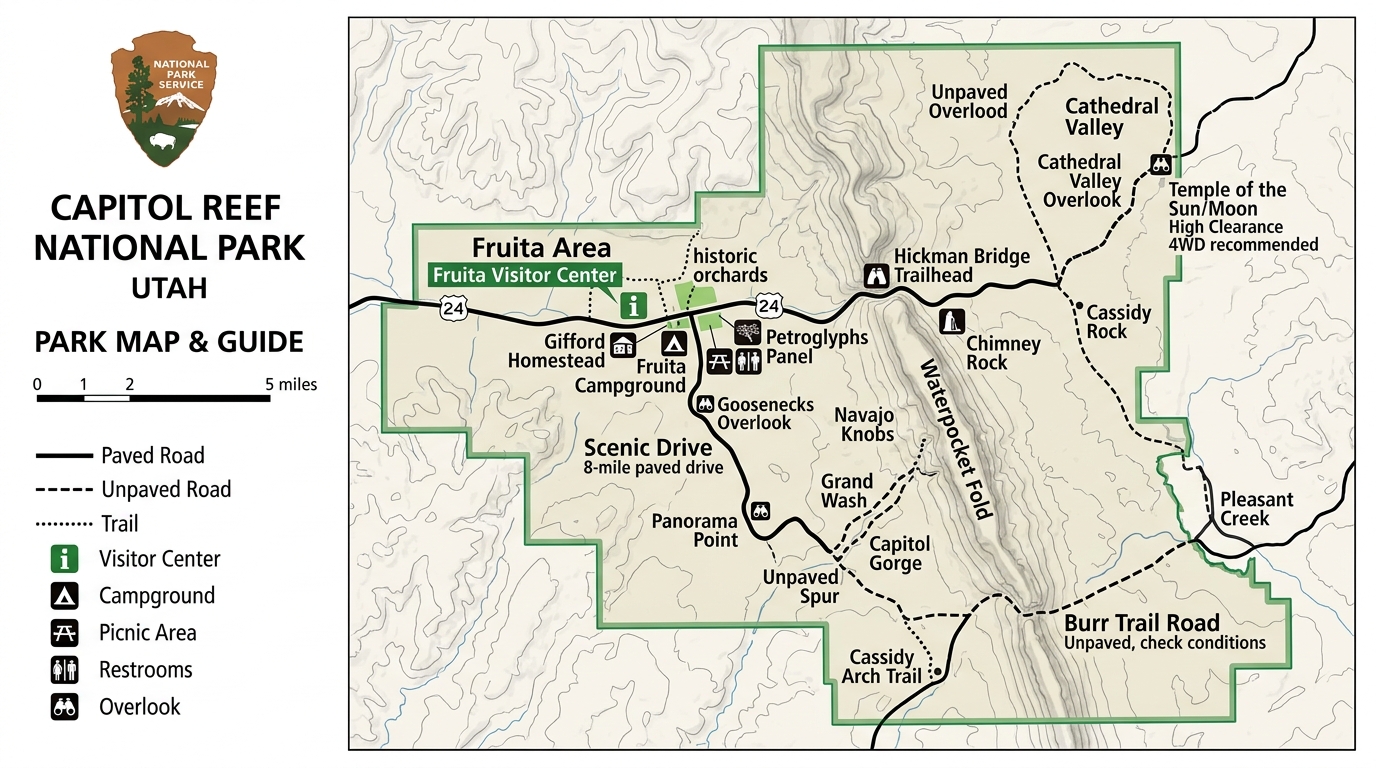
Planning a trip to Utah’s red rock country requires careful preparation, especially when traveling into areas with no cell service. Visitors often look for a reliable Capitol Reef National Park map PDF before they leave home so they can navigate without relying on mobile data. Capitol Reef National Park features a paved scenic drive alongside rough dirt tracks in remote districts. Having the right digital files ready on a phone or tablet ensures travelers stay on track even when signal bars disappear completely. Preparing ahead of time prevents the frustration of getting lost on remote desert highways where digital assistance is simply unavailable.
Sourcing Authentic Digital Navigation Files From Federal Portals
Official sources from the National Park Service provide the safest and most accurate maps for visitors.
Finding trustworthy navigation documents starts with visiting the official National Park Service website. The National Park Service hosts downloadable brochure files, regional guides, and backcountry sheets in portable document format. Third-party travel blogs sometimes offer modified images, but these can be outdated or missing crucial mileage markers. Official government pages guarantee that trail junctions, visitor center locations, and boundary lines are correct. Travelers should download these documents directly from official sources onto their mobile devices before starting their drive. Checking the publication date on the document ensures that you are using the most current version available for your trip.
Distinguishing Between Fruita Paved Corridors and Backcountry Sheets
Capitol Reef National Park requires different maps depending on whether you stay on paved roads or explore remote areas.
A standard park brochure map works well for the main Fruita district and the paved scenic drive. Visitors planning to venture into Cathedral Valley or the Waterpocket Fold need specialized backcountry guides. These remote districts feature rugged dirt tracks that demand high-clearance vehicles and precise topographical details. The National Park Service provides separate digital sheets for these unpaved routes, highlighting wash crossings, primitive campsites, and emergency exit roads. Understanding the differences between these maps helps you choose the right file for your specific travel itinerary.
| Map Type | Best Used For | Vehicle Requirement |
|---|---|---|
| Main Park Brochure | Fruita District, Visitor Center, Paved Scenic Drive | Standard Car |
| Cathedral Valley Map | Northern District, Temple of the Sun and Moon | High-Clearance 4WD |
| Waterpocket Fold Map | Southern District, Burr Trail, Strike Valley | High-Clearance Recommended |
Preparing Mobile Devices for Remote Utah Canyons
Cell service drops completely in many parts of Capitol Reef National Park, making offline preparation essential.
Digital files must be saved directly to local device storage rather than cloud folders that require an internet connection. Travelers should open each document after downloading to confirm it loads correctly and zooms in without losing text clarity. Many official map files are large because they contain high-resolution graphics and detailed trail contours. Saving copies to multiple devices, such as a phone and a backup tablet, protects against hardware failure in remote environments. Taking a few minutes to organize your digital files into a dedicated folder makes finding them much easier once you are out on the trail.
Anticipating Electronic Hardware Failures in Desert Environments
Digital files on phones and tablets can fail if batteries die or screens break in the desert heat.
Relying solely on electronic devices creates significant risks if equipment overheats or runs out of battery power in rural Utah. Extreme desert temperatures drain phone batteries much faster than normal conditions. According to National Park Service guidelines, carrying a traditional paper backup alongside digital files is always wise. Visitors should also check current weather and road conditions with rangers at the visitor center, as flash floods can render dirt road maps instantly obsolete. Being aware of these technological limitations ensures you remain safe during unexpected emergencies.
To plan your overall schedule and decide how long to stay in the region, check out our guide on the Capitol Reef National Park Itinerary planning.
Frequently Addressed Questions Regarding Desert Navigation Files
Can I download a Capitol Reef National Park map PDF on my phone?
Yes, visitors can save official documents directly from the National Park Service website to any smartphone or tablet.
Do I need cell service to view my downloaded map?
No, files saved to local device storage open without any internet connection or mobile signal.
Are standard park maps enough for Cathedral Valley?
No, Cathedral Valley requires specialized backcountry sheets that detail rough dirt roads and river crossings.
Where can I get a physical paper map if my device fails?
Physical maps are available at the Capitol Reef visitor center operated by the National Park Service.
Are official park map downloads free?
Yes, all official digital maps provided by the National Park Service are free to download.
How do I handle large file sizes on my mobile device?
Connect to a fast Wi-Fi network before your trip to download large files completely without using mobile data.
Disclaimer: Park rules, road conditions, and digital resource links can change over time. Always verify current alerts and details directly from official park sources before starting your trip.

I’m Muhammad Ubaid, founder of YBR Magazine. I research and write detailed guides on America’s National Parks — covering entry fees, permits, best times to visit, and planning tips — using official NPS sources and up-to-date information.

